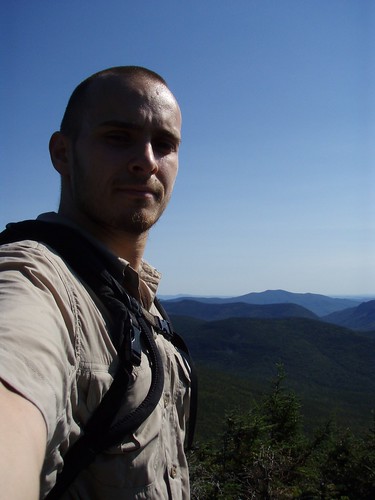
Mount Hancock (4,420') was once one of the most inaccessible mountains in the White Mountains. It was remote, void of any trails, and was devastated by logging. It's now full of life and is one incredible hike! I hiked this mountain as part of my Labor Day hiking marathon. The trail head is located off the Kancamangus Highway, just past the Greely Ponds trail, labeled the Hancock Notch Trail.
The first part of the hike, crossing mostly flat ground, was as easy as the hike up the North peak was difficult. The sound of cars along the Kancamangus Highway disappeared more quickly than I imagined they would. After 1.7 miles, I reached the trail junction of the Hancock Notch Trail and the Cedar Brook Trail. From there I traveled along the Cedar Brook Trail for 0.7 miles over slightly more rugged terrain to the junction where the Hancock Loop Trail branches off to the right. Another 1.1 miles and I reached the Hancock Loop Junction. From here on, the trails were nothing short of difficult. Just before reaching the loop junction, I passed a group of hikers on their way back who told me I should take the North peak up and the South peak down, because the rock was a lot more loose on the South peak. I had planned to take the North peak anyway, but it was nice to know a group of people survived the same route I planned on taking.
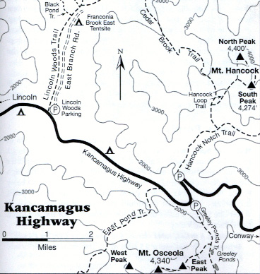
As I headed towards the North peak, I noticed in the distance a huge rock slide in the shape of a V on the mountain in front of me. I later learned (on my hike up Mount Osceola) that this was a distinguishable feature of Mount Hancock that made it easy to identify from a distance. In the back of my mind, I hoped that wasn't the trail up the mountain.
After crossing a dry river bed, the trail became more and more difficult. The most difficult and steep part was a 1/2 mile section of the hike which climbs over 1,000 ft in elevation. There are several sections of the trail that have enough trees cut to give you a taste of the view at the top. And the view at the top of North peak was incredible. Mount Osceola and Carrigain are clearly visible from here. I didn't know it at the time, but I would be climbing Mount Osceola the following day!
After a short 20 minute break, I traveled across the mountain to the South peak (4,274'), 1.4 miles away, over very easy ground (a relief after hiking North peak!). It was quite amazing how clean and untouched everything was along the trail at the top of the mountain -- it was almost fairy-tale like. When I arrived at South peak, there were nice views to the East and North, though nothing quite as panoramic as the outlook on North peak. As I descended back down to the loop junction, I could see the side of Hancock I climbed earlier, as well as the distinguishable "V" rock slide. Maybe it was just my imagination, but the decent down South peak seemed very short and not nearly as difficult as ascent up North peak. From here, I hiked back to the parking lot the way I came.
Date of Hike
2007/09/02
Hiking Time (including breaks)
Parking Lot to North peak: 2 hours
North peak to South peak: 40 minutes
South peak to Parking Lot: 1 hour 40 minutes
Hiking Distance
Round Trip: 9.4 miles
Webmentions