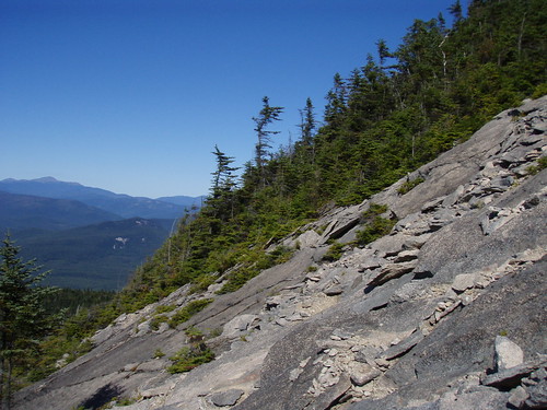
On Labor Day weekend, I hiked Mt. Tripyramid, one of the official 48 four thousand footers in NH. The trail starts out with a relatively easy 3 mile walk along Livermore Rd. I went past the South Peak trail and took the North Peak trail instead. This trail went up the very steep North Slide (which is where the above picture was taken from); the rock face was very bare in some spots, requiring me to find cracks in the rock to hold myself down as I climbed. The panoramic view from the North Slide was awesome. The Waterville Valley ski area and Mt. Tecumseh, the mountain I climbed the following day, was clearly visible. There were times on the North Slide where I had no idea where the trail was (stay to the right on the slide!) but it eventually lead to a very dense forest.
Once inside the forest, the trail almost disappeared. There was a spot where I thought the trail branched off to the right, but after getting confused and exploring it, I determined it lead nowhere. The trail continues straight up and off to the left (the maps don't show this at all) through very dense bushes (you can't even see the ground while going through them). There was one spot on a rock in the dense bushes where the view opened up to the South.
There weren't many views from the North Peak. The trail continued along the ridge through thick forest to Middle and finally South Peak. I took the South Slide back down, which had a lot more loose rock, but felt much safer than the very steep North Slide.
After the South Slide, the trail continued through the forest and eventually lead back to Livermore Rd. From there, I had the long 3 mile walk back to the parking lot.
I used a new app on my iPhone called RunKeeper to track my hike using the built-in GPS. You can see elevation, speed, and the route:

Date of Hike
2009/09/06
Hiking Time
Total Time: 5 hours 42 minutes
Book Time: 7 hours
Hiking Distance
Round Trip: 10.5 miles
Total Climb
3,289′