Mt. Jackson & Mt. Webster

On Top of Mt. Jackson

This past Monday I hiked Mt. Jackson, checking off another 4k footer from the list of 48 in NH. The trailhead was located off RT302, right next to Crawford Notch in the heart of the White Mountain National Forest. At the base, the temperature was around 40 degrees Fahrenheit, so I expected much colder temps at the summit and prepared accordingly.

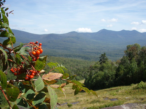
It was a steady climb up; there were only a few places where I didn't feel like I was climbing stairs. Since I was constantly moving, my body warmed up and I ended up storing most of the warm clothing in my bag during the hike. Most of the landscape was lush -- even tropical (it's hard to imagine for New England, but there are rain forests here!).

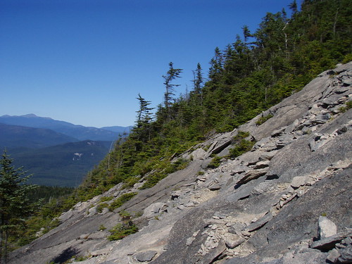
Somewhere around 3,500', I looked up and the tops of the trees were covered in something white. I realized it was ice! At the same time, I noticed the wind was blowing incredibly strong just 15' above me; the clouds, so close I felt like I could reach out and touch them, were whipping by as if on a racetrack. From that point onward, things just got colder.

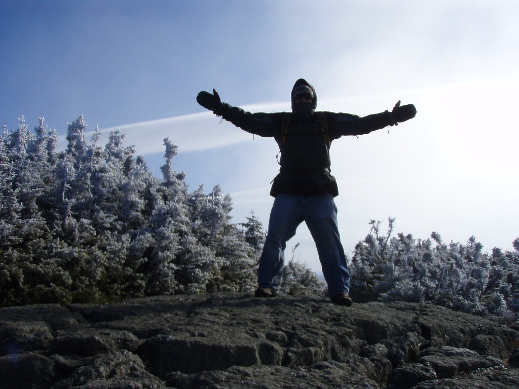
When I reached the summit, everything was frozen. It was incredible. The wind was gusting so strongly that I struggled to maintain my balance. I took off one of my gloves to take pictures and within thirty seconds I couldn't feel my fingers! There were 360-degree views of the surrounding Presidentials -- absolutely stunning.

I decided to take the Mt. Webster loop back instead of going the same way I came. It was an extra 1.6 miles, but I was in no rush. But before I left the summit, I heard a bird whistling to me. I looked over and there he was, perched ten feet in front of me on a frozen pine branch. Realizing I was on part of the Appalachian Trail, I suspected he might be accustom to being fed by passing hikers. I opened a food bar and sure enough, he ate right out of my hand!

The hike from the summit of Mt. Jackson to the summit of Mt. Webster was mostly easy-going terrain. There were lots of slippery log walkways winding through swampy areas that were overgrown with green moss. It was also still cold (the trees were still under 15', and I was still exposed to the strong winds).

Overall, it was an incredible hike. The four and a half hours felt more like eight and the changing landscape, high winds, and friendly wildlife made the trip exhilarating. I didn't pass a single person on the entire hike, probably due to the fact that it was Monday. 🙂

Date of Hike
2009/11/16

Hiking Time
Total Time (including breaks): 4 hours
Book Time: 4-5 hours

Hiking Distance
Round Trip: 5.73 miles

Total Climb
2,232′

Runkeeper Stats

Mt. Tecumseh

On Labor Day, I hiked Mt. Tecumseh, the lowest of the official 48 four thousand footers in NH. The trail starts just below the Waterville Valley ski area base camp (slightly back down the road on the right side, if you're facing the base camp). The first two miles of the trail were beautiful and well maintained. In some parts, the forest was so lush it felt tropical. After the first lookout (where the above picture was taken), the trail becomes a lot more unforgiving and you're basically doing stair climbers on rocks for a mile and a half (my thighs ached for days afterwards).

The summit area was extremely lush and the peak offered a nice view. I took a nap at the summit, snapped some pictures of a beautiful sky, watched a mouse scramble out from underneath a rock looking for scraps, and eventually ended back down.

Instead of going back the same way I came, I took the Sosman Trail over to the top of the ski trails. The panoramic view was indescribably stunning, but unfortunately by this time my camera had run out of battery. (I was, however, able to snap two pictures half way down.) Having an unobstructed view from the top all the way down to the base lodge was incredible and being on such a grassy hillside definitely made me feel like I wasn't in New England anymore. I switched between jogging, walking, and limping down the ski trails. My feet were in a lot of pain from the previous day's hike and from all the down-angled terrain, but at the same time I wanted to get down faster so the pain would cease.

Date of Hike
2008/09/07

Hiking Time
Total Time (including breaks): 4 hours
Book Time: 3.5 hours

Hiking Distance
Round Trip: 9.6 miles

Total Climb
2,328′

Mt. Tripyramid (North & South Peak)

North Slide on Mt. Tripyramid

On Labor Day weekend, I hiked Mt. Tripyramid, one of the official 48 four thousand footers in NH. The trail starts out with a relatively easy 3 mile walk along Livermore Rd. I went past the South Peak trail and took the North Peak trail instead. This trail went up the very steep North Slide (which is where the above picture was taken from); the rock face was very bare in some spots, requiring me to find cracks in the rock to hold myself down as I climbed. The panoramic view from the North Slide was awesome. The Waterville Valley ski area and Mt. Tecumseh, the mountain I climbed the following day, was clearly visible. There were times on the North Slide where I had no idea where the trail was (stay to the right on the slide!) but it eventually lead to a very dense forest.

Once inside the forest, the trail almost disappeared. There was a spot where I thought the trail branched off to the right, but after getting confused and exploring it, I determined it lead nowhere. The trail continues straight up and off to the left (the maps don't show this at all) through very dense bushes (you can't even see the ground while going through them). There was one spot on a rock in the dense bushes where the view opened up to the South.

There weren't many views from the North Peak. The trail continued along the ridge through thick forest to Middle and finally South Peak. I took the South Slide back down, which had a lot more loose rock, but felt much safer than the very steep North Slide.

After the South Slide, the trail continued through the forest and eventually lead back to Livermore Rd. From there, I had the long 3 mile walk back to the parking lot.

I used a new app on my iPhone called RunKeeper to track my hike using the built-in GPS. You can see elevation, speed, and the route:

Date of Hike
2009/09/06

Hiking Time
Total Time: 5 hours 42 minutes
Book Time: 7 hours

Hiking Distance
Round Trip: 10.5 miles

Total Climb
3,289′

Hiking Loverens Mill Cedar Swamp

On Saturday, I visited my friend Adam in NH and we spent five hours hiking in the Loverens Mill Cedar Swamp. The area was purchased by The Nature Conservancy in 1998 and the conservation was expanded in 2006.

Loverens Mill Cedar Swamp

There was a good amount of snow still on the ground and several days of mixed warm and cold weather left the snow with a firm crust but a soft core. We found ourselves randomly falling knee-deep into the snow where the crust was too weak to hold our weight, sometimes falling into hidden pools of water. (Note to self: Wear waterproof boots, not breathable boots, when hiking in the snow.)

We ventured far off the trail and found dozens of untouched boulders and amazing rock formations. These formations are commonly called glacial erratics, although there seemed to be a very strange consistency to them. Evidence of repeated camp fires scarring the rock hinted towards heavy use of the area by Native Americans hundreds, if not thousands of years ago. We even found stone arrow heads scattered around the many small caves that were created by these huge formations.

Both of us forgot to bring a camera, but I managed to take a few photos with my iPhone. We found a huge tree that had been split in half from the ice storm a few months ago and you can't really tell from the pictures, but it was so big that both of my arms only wrapped half way around! I found an interesting fact about the area: Pollen studies have shown that the Atlantic White Cedar (which is actually a cypress, not a cedar) has existed in the area for more than 4,000 years, and its presence is rare because the species is usually found in much lower altitudes.

San Luis Reservoir, Route 99, and San Francisco

Golden Gate Bridge

As I left Mojave, CA (where I comfortably spent the night in Motel6 with free WiFi for $40) and drove along route 58, I found myself surrounded by windmills. California is one of the top states for renewable energy sources and it showed.

Right after the section of hills and windmills, I went through the small flat town of Tehachapi. The most stunning sight going through this town was a group of very tall pine trees sticking up out of the ground like giant blades of grass. As I left the flat plains, the landscape quickly became hilly again, but now with a twist: the landscape was littered with stunted trees.

Stunted Trees

Route 99 was mostly surrounded by fields, the occasional section of giant trees taller than anything else in view, and flowery bushes dividing the the highway itself. I stopped in Visalia, CA to get lunch at Panera Bread and use their free WiFi. The town, like many of the towns I went through, looked like it sprang up from out of the dry desert. People flocked to the new stores (Starbucks, Target, and Lowes are visible in the pictures) with their kids, many dressed in what looked like local farming clothes. It was easy to differentiate between long-time residents and the new people.

Visalia, CA

Going through Los Banos on route 152, huge winding canals carried water and looked like paved roads of their own. The San Luis Reservoir appeared out of no where and route 152 snaked around half the reservoir, climbing up the hills and opening up to amazing views. As I came down the other side of the hills, the landscape became thickly forested for a short while, no doubt fed by the water from the reservoir.

San Luis Reservoir

Entering the San Francisco area on route 101, the weather turned extremely cold; 55 °F! I had spent the past two days driving in 100+ °F weather and the change was a huge shock. The pine trees in Mountain View (considered part of Silicon Valley, home of Google, Microsoft, and others) made it clear that I was no longer in the desert. Many parts felt eerily similar to New England, except that everything was extremely clean and lots of people had hybrids and rode their bikes.

I then drove into San Francisco, a very hilly and foggy city. Much of the city smelled like burning firewood from the forest fires. I drove over the Golden Gate Bridge and took the first scenic stop on the right. I'm sure the views would have been even more incredible if it wasn't so cloudy.

Golden Gate Bridge Monument

There is a huge section of trails to the West, but I didn't have enough time to explore further. I headed back to the airport, returned the rental, and waited for the plane (it was delayed one hour). The plane left at 12:30am. Being a flight to Boston, MA, they offered Dunkin Donuts coffee on the flight. I hoped to get some sleep on the way, however the flight was very turbulent. I'm talking 30+ minutes of non-stop turbulence. People were vomiting, and even I was starting to feel sick (I don't get motion sickness very easily). The pilot tried going around it, but couldn't. Never the less, we landed safely in Boston at 8:30am and I took public transportation back to Central Square for $1.70. It took 35 minutes and we passed a $3.50 toll along the way. It was amazing how small everything looked when I got back; the rivers, the roads, the buildings, everything looked smaller.

California was an amazing place of diversity and I really look forward to going back. I'd like to live there at some point in the future.

Total miles driven: ~420

2008-06-23 Travel Map

Mojave Desert and Death Valley

Raam in Death Valley

I don't know what it is, but I love the desert. Endless roads, warm air (115°F), wind (it's hard to tell but in the picture above the wind is blowing 30+ mph), flat land that seems to go on forever, and of course, very few people.

Crossing the the border between Nevada and California, a desert mirage looked like a giant lake. A few minutes later, I spent about an hour covering 10 miles of I-15 due to a truck that turned over going through Mountain Pass. I entered the Mojave Desert from the North through Cima, CA. The US Post Office for Cima looked more like a shack in the middle of the desert until I saw the original Post Office:

US Post Office for Cima, CA

I tried driving up a dirt road, but turned around half way when I realized there was a chance I could get stuck (I had a Toyota Camry). So much for my sense of adventure.

Driving on I-40 the views were incredible (and so was the heat).

Before entering Death Valley, I thought of filling my gas tank. I decided to skip it when I saw the gas price was 4.91. Later, in Shoshone, CA, I ended up buying gas for 5.39 a gal. The sun was setting fast (and the smoke from the forest fires didn't help) and I wanted to get through Death Valley before the sunset.

The mountains and roadside were more barren than ever going through Death Valley. I read signs that said to be aware of the extreme heat and along a particular stretch of road there were "radiator water tanks" every few miles. I was passing through around 7PM and it was still 115 degrees, so I can't imagine how hot it must have been during the day.

Barren Death Valley

I was only half-way through Death Valley when it got dark. A big section of route 190 was through the mountain with roads that curved left and right a thousand times. Many of the corners had no guard rails and whenever I dared to take my eyes off the road and look down, all I could see was pitch black. It was definitely nerve racking going around each corner not being sure if there was a big rock lying in the middle of the road (plenty of signs warned me of that possibility). I saw dozens of snakes crossing the road during the night, but decided not to get a closer look and risk being stung in the middle of no where.

As I exited Death Valley and approached 395, I could see the mountains to the West glowing orange. I quickly realized they were forest fires and pulled over to take some pictures (timer, 30 sec exposure, the roof of the car, and the camera strap for balance). After taking the pictures I drove South on 395 and ended up going through all the smoke from the forest fires. Driving on the highway at 75 MPH in 110 degree weather, white ash started falling like snow. Animals that were running to escape the fire were on the left and right side of the highway. As I approached them, they would look up at me; their blue, gray, and green eyes shining through the thick smoke. It was very surreal.

Forest Fires

Total miles driven: ~580

2008-06-22 Travel Map

Vegas, Lake Mead, Valley of Fire, and Hoover Dam

Bellagio

Friday night Sanjay dropped me off in front of the Bellagio on his way to the airport. The Strip was crowded as hell. I noticed everyone was looking out towards the Bellagio and realized they were waiting for the fountains to start. I found a good place to steady my camera and when it started I took some photos of the fountain.

Then I looked for the fastest, cheapest way out of there! It had only been about 20 minutes and I was already sick of the place. I took the monorail back to the Hilton for $5 and then caught a cab to the Plaza Hotel, which was North of The Strip. $12 including tip.

The Plaza Hotel was crap. I got a smoking room (they didn't ask me what I wanted), the TV was broken (it turned on and off randomly), and when I fell asleep with the TV on, a security guard opened my hotel room door, woke me up and asked me to turn down the TV... at 2:30 in the morning.

The next morning I needed to find a way to the airport to pick up my rental car. The person at the front desk said the shuttle to the airport arrives every 1.5 hrs and that a cab costs about $25 to the airport.

After having a coffee and waiting around a bit inside, I decided to get some fresh air and sit outside (the ceiling of the place was covered in bulbs). When I asked the security guard about the shuttle, she said it arrives every 30 minutes, but that it will most likely be full because it requires that you reserve a spot. She also said it has lots of stops and that it will take awhile to get to the airport. She said a cab is about $40 and that I should take the city bus; it comes every 30 minutes and is a lot cheaper. However it's a long 1 hour ride to airport because it makes lots of stops.

So I walked half a block and waited for city bus. When it arrived, I realized I only had a $1 dollar bill and a $20 bill (fare was $1.25). The driver said he has no change and that I should go find change elsewhere. As soon as the bus drove away, I realized I had 25 cents in my LEFT pocket (normally I only put money and change in my right pocket).

So I decided to wait for shuttle and ask the driver if there was room. He came 10 minutes later, I paid him 8 bucks. I was the only one on the shuttle, and he went straight to the airport in 15 minutes.

There was a single building for all the car rentals and the place looked like a mini airport! There were about 100 people in line for the shuttle back to the airport.

When I purchased something at the concession stand, the persona at the register said, "Have the best day!" instead of, "Have a good day!". I later realized a lot of people in Nevada said "Have the best day".

The car I rented was a Toyota Camry. It was rated at 35 MPG (I later tested my real fuel economy and discovered I was getting 37 MPG). The rental for three days was a bit expensive, but since I knew I would be doing around 1,000 miles and with gas prices where they were (between 4.50 and 5.80 a gal out West), having good fuel economy would definitely be worth the extra cost (I ended up doing 1,241 miles over the three days).

Toyota Camry

After picking up the rental, I drove towards Lake Mead on E Lake Mead Pkwy and then realized a better route would be to come down through the Valley of Fire. So I went back, took I-515 North to I-15 North, and came down route 167 through Logandale and Overtron.

Valley of Fire

Finally, I took route 147 to 166, and then onto 93 where I visited Hoover Dam. They were rebuilding the 93 highway with a new bridge that goes across the dam. I can see why. The current roads are very narrow and easily create a bottleneck in the flow of traffic.

New 93 Bridge over Hoover Dam

I stopped briefly in Boulder City (which was beautiful) and then found a place to stay in Henderson, NV called Hawthorne Inn. This room was much, much nicer than the Plaza Hotel and it only cost me $50!

I will let the pictures and the map do the rest of the talking. Keep in mind that I took the majority of the pictures while driving. I just held my DSLR in one hand, and stuck it out the window over the passengers seat (yes, I kept a hand, and my eyes, on the road). Keeping the camera level was difficult and I had to learn how to judge where I was pointing the camera without actually looking through the viewfinder. With the amount of driving I was planning on doing, I couldn't afford to stop and take pictures!

Total miles driven: ~240

Route Driven 2008-06-21

InfoComm 08 in Las Vegas, NV

InfoComm 08 Booth

I went to Las Vegas, NV last week to attend InfoComm 08, the largest Pro AV show in history.

We arrived Tuesday morning and setup the booth without much difficulty. I have set up many show booths in my lifetime (my parents used to attend gift shows every year around the country) and setting up the booth in three hours was a breeze compared to the ten-plus hours it would take to setup my parents booth.

The following three days consisted of me doing a lot of standing between 9AM and 5PM:

Raam at InfoComm 08

The experience was not much different from the gift shows I had attended. Instead taking orders for product hanging on the walls, I needed to ask (and answer) questions about the company's product and talk to the people who came by the booth.

My boss let me take breaks to walk around the show and I saw lots of really nice screens and cool technology. One booth was selling remote control helicopters with HD cameras attached to them. He flew the smaller one around his booth and over peoples' heads while I was there. That's one way to attract a crowd of men who are fascinated by technology! Unfortunately I didn't take my camera with me, so I don't have many pictures of the show itself.

Taking down the booth was just as easy as putting it up, but we had to wait a good two hours for our boxes to arrive. Once we had the boxes we were out of there in an hour. My boss was flying back later that night and I planned to walk The Strip and then find a room for the night.

Mount Osceola

Mount Osceola (4,340'), named after an Indian war chief of the Seminole Indians in Florida (misappropriation of Native American names was not unusual in the 19th Century), was an excellent half-day hike. The Mount Osceola Trail branches off the Greely Ponds Trail and is accessible from the Greely Ponds trailhead.

The trail quickly started its ascent, becoming quite steep at times, with the East peak looming overhead. When I did finally reach the East peak at 4,156', the in-your-face panoramic view was both incredible and dizzying. The East peak view point is extremely steep; a huge jagged clump of rocks angled in such a way they seemed to shout "don't trip here, or it will be a painful slide down!". Upper Greely pond is also visible from here and having visited it only an hour earlier made me appreciate the distance that much more.

After another short burst of unforgiving, steep trail, I reached the summit-with-views. I call it that because the true summit, which can be seen from here and is a relatively short and easy hike, has very limited panoramic views.

I didn't stay at the summit long and decided to take a break at the summit-with-views instead. Amazingly, the Northwest side of Mount Washington, the highest peak in the American Northeast, can just barely be seen from here (center of picture, behind the foreground peak, just barely visible).

Also visible from here, and probably more incredible for me, is Mount Hancock, which I climbed the previous day. It has a distinguishable “V” rock slide, which can be seen in several of the pictures I took from Mount Osceola. The V can be seen in the center of this picture and here is a closeup of the rock slide I took the previous day.

Date of Hike
2007/09/03

Hiking Time
Parking Lot to East peak: 50 minutes
East peak to Summit: 30 minutes
Total Time: 2 hours 40 minutes
Book Time: 4 hours

Hiking Distance
Round Trip: 5.6 miles

Total Climb
2,250'

Upper Greely Pond

This hike was part of the three days of hiking I completed this past Labor Day weekend. I wasn't actually planning to visit Greely Pond. In fact, I was on the trail to hike Mount Osceola (I'll post that next). However it was only a short, 0.3 mile detour to Upper Greely Pond, so I decided to go for it.

The trail leading to Upper Greely Pond was simple enough, though it did require walking over log bridges and crossing streams along the way. Mount Osceola's East peak soars above the pond and is where I was headed next.

The two ponds, Upper and Lower Greely Pond (I only visited the Upper pond) are nestled inside Mad River Notch. The Greely Pond Trail actually leads all the way across to Waterville Valley, about 3 miles away.

Mount Hancock (North and South Peaks)

Mount Hancock (4,420') was once one of the most inaccessible mountains in the White Mountains. It was remote, void of any trails, and was devastated by logging. It's now full of life and is one incredible hike! I hiked this mountain as part of my Labor Day hiking marathon. The trail head is located off the Kancamangus Highway, just past the Greely Ponds trail, labeled the Hancock Notch Trail.

The first part of the hike, crossing mostly flat ground, was as easy as the hike up the North peak was difficult. The sound of cars along the Kancamangus Highway disappeared more quickly than I imagined they would. After 1.7 miles, I reached the trail junction of the Hancock Notch Trail and the Cedar Brook Trail. From there I traveled along the Cedar Brook Trail for 0.7 miles over slightly more rugged terrain to the junction where the Hancock Loop Trail branches off to the right. Another 1.1 miles and I reached the Hancock Loop Junction. From here on, the trails were nothing short of difficult. Just before reaching the loop junction, I passed a group of hikers on their way back who told me I should take the North peak up and the South peak down, because the rock was a lot more loose on the South peak. I had planned to take the North peak anyway, but it was nice to know a group of people survived the same route I planned on taking.

As I headed towards the North peak, I noticed in the distance a huge rock slide in the shape of a V on the mountain in front of me. I later learned (on my hike up Mount Osceola) that this was a distinguishable feature of Mount Hancock that made it easy to identify from a distance. In the back of my mind, I hoped that wasn't the trail up the mountain.

After crossing a dry river bed, the trail became more and more difficult. The most difficult and steep part was a 1/2 mile section of the hike which climbs over 1,000 ft in elevation. There are several sections of the trail that have enough trees cut to give you a taste of the view at the top. And the view at the top of North peak was incredible. Mount Osceola and Carrigain are clearly visible from here. I didn't know it at the time, but I would be climbing Mount Osceola the following day!

After a short 20 minute break, I traveled across the mountain to the South peak (4,274'), 1.4 miles away, over very easy ground (a relief after hiking North peak!). It was quite amazing how clean and untouched everything was along the trail at the top of the mountain -- it was almost fairy-tale like. When I arrived at South peak, there were nice views to the East and North, though nothing quite as panoramic as the outlook on North peak. As I descended back down to the loop junction, I could see the side of Hancock I climbed earlier, as well as the distinguishable "V" rock slide. Maybe it was just my imagination, but the decent down South peak seemed very short and not nearly as difficult as ascent up North peak. From here, I hiked back to the parking lot the way I came.

Date of Hike
2007/09/02

Hiking Time (including breaks)
Parking Lot to North peak: 2 hours
North peak to South peak: 40 minutes
South peak to Parking Lot: 1 hour 40 minutes

Hiking Distance
Round Trip: 9.4 miles

Little Haystack via Falling Waters Trail

Me on Little Haystack

Little Haystack (4,840') is a part of the Franconia Range in the White Mountains of New Hampshire. I hiked to this peak with my sister Meera and my brother-in-law Thea.

We started the hike from the Old Bridle Path parking lot, which is located off I-93N. The exit is marked "Trail Head - Old Bridle Path". From there, we took the Falling Waters Trail to the peak of Little Haystack. The trail varied between being easy and difficult and we passed several waterfalls along the way. I was disgusted by how inconsiderate some people are, leaving a bag of trash under a rock along the trail. I later regretted not taking the bag back to the parking lot with me when I realized I could have done something to help protect the environment.

Since I am someone who is often bothered by the knowledge of germs, I was taken aback when I noticed how every tree that was positioned in the right place to assist people along the trail, was soaked with oil from the many hands that had come in contact with it. I avoided these trees at all cost for the rest of the hike, as well as on my other hikes.

Trail Map

When we arrived at the top of Little Haystack, above the alpine zone and above the tree line, the temperature dropped dramatically. It was about 85 degrees when we started the hike and at the top, with the fierce wind, it was around 30 degrees! Everyone was wearing winter hats and winter clothes. I was freezing, but I was happy I remembered to bring a sweatshirt! The other two peaks, Mount Lincoln and Mount Lafayette, are both visible from the top of Little Haystack. You could even see the parking lot where we started. Due to the cold weather, we decided not to hike any further and went back down the Falling Waters Trail the way we came.

Date of Hike
2007/09/01

Hiking Time (including breaks)
Ascend time: 2.5 hours
Descend time: 1.5 hours

Hiking Distance
Round Trip: 7 miles